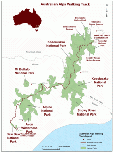
The Australian Alps has hundreds of fantastic trails. The iconic long distance trail is the Australian Alps Walking Track, which stretches from Walhalla, east of Melbourne, almost to Canberra. The AAWT was created in stages, starting with the Victorian Alpine Walking Track, which was developed in the 1970s as part of a larger vision of linking the Australian Alps with a three-state trail. The dream of a long distance track was only fulfilled after years of work and a lot of ‘big picture’ thinking by many people.
Now there are plans to extend the track network all the way to Melbourne and right into Canberra. There are two alternatives for the track from Melbourne, and a proposed route into Canberra, which are outlined below. This well researched proposal identifies gaps in existing tracks and a number of options for connecting up with the existing AAWT.
CONNECTING MELBOURNE AND CANBERRA TO THE AUSTRALIAN ALPS WALKING TRACK – A REPORT ON PROPOSALS
By Geoff Mosley and Garry Fitcher
INTRODUCTION
The Australian Alps Walking Track (AAWT) is one of Australia’s main long distance walking tracks. As the name suggests it traverses nearly all of Australia’s Alpine National Parks from Walhalla at the foot of Baw Baw National Park in Victoria through the Alpine and Kosciusko National Parks to Tharwa close to Namadgi National Park in the ACT, a distance of about 680 kilometres (map distance). Over the years several suggestions have been made about the development of linking tracks to the AAWT. Two of these concerned the idea of establishing links from the coast, one in East Gippsland and the other in the Far South Coast region of New South Wales. The latter would be similar to the ancient Aboriginal track known as The Bundian Way running from a point near Eden to the centre of the alpine region that has now been ressurected. These suggestions were rightly referred to as ‘Sea to Snow’ tracks.
This report is concerned with establishing walking track links to the AAWT from both Melbourne and Canberra, in the former case as another ‘sea to snow’ proposal. The suggestions about how such links might be achieved are in no way meant to suggest alternative routes for the AAWT itself, since the present end points at Walhalla and Tharwa are entirely appropriate for this alpine trek.
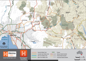
Two main alternative routes are suggested for linking Melbourne to the AAWT by way of Warburton and the Upper Yarra Track (UYT). The first by way of the Yarra River Valley, the Mullum Mullum Creek and the Warburton Trail (track along the old Lilydale to Warburton Railway established in 1996) is largely in place although there are several gaps that need to be addressed. The other possible route is a longer-term project with several alternative courses described here.
Both of these major alternatives would take the walker travelling east from Melbourne to the start of the Upper Yarra Track at Warburton and from there up to the AAWT north of Mt Whitelaw in Baw Baw National Park. When it was opened in 1907 the Upper Yarra Track (UYT) was one of the first long walking tracks in Australia. At that stage it began at McVeighs Hotel near Reefton and extended 56 kilometres to Walhalla. The establishment of the Upper Yarra Reservoir drowned part of the original Track and catchment restrictions led to the adoption of a different route for a longer UYT starting at Warburton in its western section. For several years there has been a proposal for an alternative route from Warbuton (see A.4) that would link up with the eastern section of the UYT by means of an existing track on the decommissioned O’Shannassy Aqueduct and a new track route from the O’Shanassy Weir along the northern part of Boundary Road to the present UYT at the junction of Boundary Road and the Whitelaw Track. The report also considers the advantages and feasibility of this proposal.
The responsibility for the upkeep of the Upper Yarra Track is divided as follows: 1) for the Track from Warburton to The McCarthy Spur Road – Department of Environment and Primary Industry DEPI, Forestry at Powelltown; 2) for the Track from McCarthy Spur Road to Frangipanni Saddle – DEPI, Forestry at Noojee; and 3) for last part of section 8 of the UYT (see A2 below) to the AAWT – DEPI, Parks Victoria at Traralgon.
In addition to dealing with gaps and alternative routes this report examines what work is needed to bring the UYT up to good overall standard by means of track maintenance (see A.5).
Many of those who have walked the AAWT northwards to Tharwa would have liked to have continued their walk to the centre of Canberra so in this report we also consider two alternative routes for that.
THE ‘SEA TO SNOW’ WALK FROM MELBOURNE TO THE AUSTRALIAN ALPS WALKING TRACK – THE DIRECT ROUTE (‘THE YARRA WAY’) TO WARBURTON AND THE BEGINNING OF THE UPPER YARRA TRACK
A.1 ROUTE The most direct route from Melbourne to Warburton and the start of the Upper Yarra Track leading to the AAWT is as follows:
1) Starting from the Princes Bridge at Southbank (located on a tidal section of the Yarra River) along the Capital City Trail to Dights Falls. An alternative initial route from Princes Bridge at Federation Square along the north bank of the Yarra to MacRobertson Bridge is the Main Yarra Trail (which starts near the mouth of the Yarra River near the Westgate Bridge), At MacRobertson Bridge the Main Yarra Trail becomes a shared trail with the Capital City Trail to Dights Falls. Here the two Trails separate, the Capital City Trail heads north along the Merri Creek and the Main Yarra Trail heads east.
2) From Dights Falls along the Main Yarra Trail via Westerfolds Park to the northern end of Mullum Mullum Creek Trail near Petty’s Orchard .
3) From start of Mullum Mullum Creek Trail to near the start of Warburton Trail via Mullum Mullum Creek Trail, Nursery Road, Alto Avenue, Railway Crescent, Lincoln Road, Mt View Parade, Croydondale Road, Hull Road, Lakeview Reserve, Lillydale Lake Reserve and Old Gippsland Road (see A.3 for gap).
4) From near western end of Warburton Trail along the Trail to Warburton Caravan Park.
Total distance from Princes Bridge to the Caravan Park is approximately 106 kms.
A.2 THE UPPER YARRA TRACK FROM WARBURTON TO THE AAWT
This Track starts at the Warburton Caravan Park close to the Warburton Trail and runs to the AAWT near Mt Whitelaw. From the Warburton Caravan Park along the Upper Yarra Track to the AAWT at a point 2 kms north of Mt Whitelaw the distance is approximately 81.5 kms (see A.4 for an alternative route to the first 50 kms).
The Track sections and distances (see Reference for description of each section) are as follows:
1) Warburton Caravan Park to Big Pats Creek Picnic Area (6.5 kms);
2) Big Pats Creek to Starling Gap (9 kms);
3) Starling Gap to New Federal Mill (9.5 kms);
4) New Federal Mill to Boundary Road (14.5 kms);
5) Boundary Road to Smith’s Clearing (13 kms) – the proposed alternative route (A.4) follows the Boundary Road north from the junction of Boundary Road and Whitelaws Track about 3 kms before Smith’s Clearing (total distance 50 kms from Warburton);
6) Smith’s Clearing to Road 12 (14 kms);
7) Road 12 to Thomson River (11 kms);
8) Thomson River to AAWT (9 kms).
A.3 TRAIL GAPS AND THEIR FILLING
1) There is an existing gap on the Mullum Mullum Creek Trail between Park Road and Heads Road that the Manningham City Council plans to fill by 2017. A temporary route can be used on the east side of the Creek via Park Road and the Melbourne Water pipe track;
2) There are major gaps between the end of the Mullum Mullum Creek Trail and the beginning of the Warburton Trail. The established trails in this section are intermittent but there are several opportunities to close the gaps. One is to utilise the about to be constructed by Vic Roads shared use path between Bayswater and Lilydale along the Melbourne Water pipe track and the Healesville Freeway reserve. This proposal is to connect to this path via Mount View Street and the Town Park in Croydon.
Another opportunity is associated with the proposed redevelopment of land around the Cavehill Quarries. A concerted effort is required to close these existing gaps and it has been suggested that a link track extending all the way from the eastern end of the Mullum Mullum Trail to near the start of the Warburton Trail could be known as ‘The Melba Link Trail’ (acknowledging the association of Dame Nellie Melba with this area).
A.4 TRACK VARIATIONS
A few years ago it was suggested by departmental staff that the current Upper Yarra Track might be changed in its western section to something closer to its original route but still linked with Warburton (see map of alternative route ). The first part of this possible variation involved utilising the existing O’Shannassy Aqueduct Trail in the Parks Victoria managed Yarra Ranges National Park. From this Trail, after crossing the Warburton to Woods Point Road and the Yarra River between McMahons Creek and Reefton, the proposed new track route would follow the northern section of Boundary Road and connect up with the existing UYT at the junction of Boundary Road and Whitelaw Track (from there the UYT would be unchanged). This point is 50 kms from the Warburton Caravan Park via the existing Upper Yarra Track. The proposal was discussed with Bushwalking Victoria. Since this would involve a section of the track being in the restricted catchment, enquiries are being carried out to see what changes to regulations would be required before this section could be used.
A.5 TRACK MAINTENANCE
Regular track maintenance is essential every two to three years. In general the tracks along this route are in a good condition. The greatest need is along the Upper Yarra Track where shrub growth can readily obscure the route and make passage difficult. A table showing the condition of the different sections of this track is provided in Appendix 1.
ALTERNATIVE ROUTES FROM MELBOURNE TO THE AUSTRALIAN ALPS WALKING TRACK VIA WARBURTON
There are several possibilities for a more northern route from Melbourne to Warburton. One of these for instance could include Mt Sugarloaf, Mt St Leonard and Mt Donna Buang. Another could utilise a track along the decommissioned Maroondah Aqueduct. These routes have not been fully investigated or decided on and there are major gaps between some of the existing and proposed tracks. As a result these can only be regarded as long term projects and the following suggestions are outlined in that spirit. While they are mentioned here as alternatives it is believed that a strong case exists for the development of both tracks. More information about the Kinglake Way, the Maroondah Aqueduct Trail, the Green Wedge Trail and the Diamond Creek Trail extension can be found in the 2011 Nillumbik Trails Strategy.
B.1 THE MANY PEAKS TRACK VIA KINGLAKE NATIONAL PARK
ALTERNATIVE
1) From Southbank same route as in A.1 as far as Fitzsimons Lane (Westerfolds Park), then Diamond Creek Trail to Diamond Creek;
2) From Diamond Creek the proposed Diamond Creek Trail extension to Hurstbridge (Nillumbik Shire Council – proposed completion date of 2018); then proposed Kinglake Way to Kinglake National Park/Mt Sugarloaf (under investigation by Nillumbik Shire Council). When Diamond Creek Trail extension is completed: from Hurstbridge, Haleys Gulley Road, Bannons Lane, Creighton Way, Brocks Road, Middle Hut Road, Running Creek Road to Mt Sugarloaf. Possible temporary route from existing Diamond Creek Trail to Creighton Way via Gipson Street, Broad Gully Road, Black Gully Road, Millthorpe Road, Astons Road, and Bannons Lane. A direct track from the present northern end of Running Creek Road up an unused road reserve is under consideration.
3) From Mt Sugarloaf via Mt Sugarloaf Ridge Track, Pine Ridge Track, Beale Avenue, across to Bowden Spur Road, Whittlesea – Kinglake Road to start of the Mount Jerusalem Track one and a half kms south of Kinglake. Then along Mount Jerusalem Track to its junction with Old Kinglake Road at the former Steels Creek Picnic Area. Note – an alternative to this route avoiding the climb up Mt Sugarloaf would be via Eagles Nest Road, Chads Creek Road to Beale Avenue. Another option, further south, is from the proposed Diamond Creek Trail extension at Wattle Glen on the proposed Green Wedge Trail (Nillumbik Shire Council) to Kinglake National Park boundary and cross country (no track as yet) through the Kinglake National Park to the Mount Jerusalem Track;
4) From the former Steels Creek Picnic Area, Steels Creek Road, Pinnacle Lane and Dixons Creek, Bedford Road, Paul Range Road, Healesville to Kinglake Road, Weasel Creek road (four wheel drive track), Monda Road to its junction with the Mt St Leonard summit track;
5) From Mt St Leonard, Monda Track, Mt Monda, Dom Dom Saddle, Road 8 (temporarily closed), Mt Vinegar, The Knobs, Mt Boobyalla, Mt Donna Buang, Summit Walking Track, Mt Victoria, Mt Victoria Walking Track, Martyr Road, Warburton. Caravan Park. Some parts of this section require regular track maintenance.
B.2 THE AQUEDUCT TRAIL ALTERNATIVE
1) From Southbank same route as in A.1 as far as Fitzsimons Lane, then Diamond Creek Trail to a point between Eltham North and Diamond Creek, proposed Aqueduct Trail – part of old Maroondah Aqueduct (Nillumbik Shire Council), Maroondah Highway, Fernshaw, Morley Track, Road 8, Mt Donna Buang. Warburton. Work has commenced on this Track that will eventually reach the border of the Nillumbik Shire overlooking Yarra Glen. The route from here to Healesville has not been investigated. The Yarra Ranges Council in May 2016 investigated a trail that included a section from Healesville via Badgers Creek to link up with the Lilydale to Warburton Rail Trail. These proposals have merit in their own right.
- CONNECTING THE AUSTRALIAN ALPS WALKING TRACK TO CANBERRA
The main route for the journey from the end of the AAWT at the Namadgi National Park Visitors Centre (Tharwa) to Canberra’s Civic Centre is via the Murrumbidgee Corridor, and Tuggeranong as follows:
1) From the Visitor Centre along unmarked route to Point Hut Crossing, from Point Hut Crossing along Murrumbidgee Discovery Trail to Tuggeranong, from Tuggeranong either along direct trails to Civic, or by the more circuitous Centenary Trail to Civic . From the Tuggeranong Town Centre this section of the Centenary Trail runs east of Mt Wannniassa, west of the Issacs Ridge Nature Reserve, east of both Mt Mugga Mugga and the Red Hill Nature Reserve to Parliament House from where the walker can continue on to Civic Centre (total distance Tuggeranong Town Centre to Civic Centre about 28 kms);
2) An alternative, longer but more scenic and historically more interesting, walk involves following the same route from the visitor centre as far as Point Hut Crossing, continuing along the river bank to Kambah Pool, then via Mt Arawang, the Coolemon Ridge Nature Track, crossing the Namitjara Drive, following the equestrian track running to the west of Mt Taylor and the western edge of Lyons, crossing the Cotter Road, crossing the Lady Denman Drive, crossing Dunrossil Drive near the gate to Government House, passing over a footbridge to reach the southern shore of Lake Burley Griffin, through the Westbourne Woods (Royal Canberra Golf Club over fence on right), passing by the Yarralumla Gallery and Café and the Yarralumla Nursery, crossing Weston Park Road, then via Yarralumla Bay, and Lotus Bay to the Commonwealth Avenue Bridge and from there over the Lake to Civic Centre.
3) GAP There is no marked track or trail from Tharwa to Point Hut Crossing and this section needs to at least be marked.
Reference for Upper Yarra Track: The Upper Yarra Track (1992) Department of Conservation and Natural Resources.
Acknowledgements:
The assistance of the following is gratefully acknowledged:
Carlie Trotter and Campbell Phillips (Wild Magazine), Doug Hooley, Andy Gillham, Wally Notman and Rob Patrick (Department of Environment and Primary Industry), Geoff Kelly, Bill Lord, Stuart Brookes, Stuart Ord, Lorraine Tomlins, Gosta Lynga and Doug Wright (Canberra Bushwalking Club), and Ann Turner, Murray Sinderberry and Bob Peterson (Maroondah Bushwalking Club).
Other contacts have included:
Plan Cavehill (Eleanor Howe), Nillumbik Shire Council (including input into the Northern Regional Trails Strategy), Shire of Murrindindi, Shire of Yarra Ranges, Manningham City Council, Maroondah City Council, Baw Baw Shire Council, City of Whitehorse, Outdoors Victoria, Victoria Walks, Chris Taylor and Lisa De Kleyn.


February 23, 2017 at 8:06 am
Awesome! Though Sydney will want its link too:)
February 24, 2017 at 10:38 am
Re: The Canberra connection from namadgi visiors center to kambah pool a shared camp site with centenary trail and Bicentennial trail users and idea of alpine walking track. An ideal area for camp site would in the pine island area behind the tuggeranong town center. This area is in the bullen nature reserve private and very scenic under the management of Act environment and midway between namadgi visiors center and yarralumla
February 25, 2017 at 11:24 am
The above sounds fabulous. On a smaller scale consider a track from Traralgon to Walhalla, This would provide walkers with excellent public transport access to the AAWT. Walhalla would serve as an overnight stop thus boosting the towns economy
[Yes, what a great idea. Cam]
February 27, 2017 at 2:34 pm
Facing North: Bimberdong to Parliament House Canberra
I recently walked from my home on the outskirts of Melbourne to Canberra, using the AAWT for most of the journey (a total distance of approximately 750kms). I walked via Yarra Glen, across to Healesville and onto the Morley Track (Yarra Ranges NP) at Fernshaw Picnic Area. Through Cotter Gap, then down to the Acheron River and over Mt Strickland to the O’shanessey River (playing ‘chicken’ with the logging trucks!). North to Big River, then up Frenchman’s Spur to Mt Matlock and Woods Point. Forded the Goulburn and Black Rivers and joined the AAWT at Mt Skene / Rumpff Saddle. This is a more direct route to the AAWT from Melbourne than those being proposed.
Running out of time at the other end, I simply walked beside the road and onto those soft, grassy lawns at Parliament House in Canberra.
[Wow. Thats an epic walk, John.]
October 8, 2020 at 8:57 pm
I wonder the worth of mixing urban trails with the Australian Alps Walking Track. The track as it currently exists is (un) managed by too many authorities that don’t meet their obligation to keep it in a reasonable open condition from end to end.
The track’s current and biggest threat is bushfire damage. Regrowth from fire damage is rapid making for impenetrable scrub that often goes years without clearing. That with falling burnt timber a safety corncern often leads to authorities closing sections of the track for months or years. Currently the section of the Namadgi National Park in the ACT that the AAWT passes through is closed till September 2023. Reasons by different parties are numerous, ranging from safety, regeneration and lack of funds.
In its original form the AAWT ran from Walhalla in Victoria to Tom Groggin on the NSW border. It was managed by parks and forestry authorities with help from bush walking club volunteers and has always been ran on a shoe string. Then and now it has been the domain of a few that want to explore the lonely corners of the Australian Alps. I worry bringing it into urban areas will see funding polarised towards the two ends with most traffic and the unseen remote areas will face more neglect as we face more challenges from global warming. I believe the track should retain its current rural mountain start and finish and that funds would be better directed to keeping the track open end to end as much as possible and not complicating this with urban needs and demands.