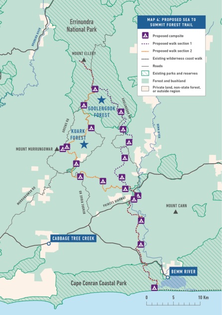
The campaign for the Emerald Link park in East Gippsland aims to protect the more-or-less intact ecosystems that run from the coast to the mountains. A long distance walking trail is an integral part of the proposal. The proposed Sea to Summit Forest Trail would create a network of walking tracks linking the coastal town of Bemm River and the existing Wilderness Coast walk to the summit of Mount Ellery, the highest mountain in far East Gippsland.
For further information on the park proposal please see the Emerald Link campaign website.
The vision for the Sea to Summit forest trail:
Being the only place on mainland Australia with continuous forest from alpine to coastal environments is a major drawcard for people craving wilderness and nature-based experiences.
Protecting these continuous forests would bring great conservation tourism opportunities and attract conservation tourism investors and businesses.
The proposed Sea to Summit Forest Trail creates a network of walking tracks that link the coastal town of Bemm River and the existing Wilderness Coast walk to the summit of Mount Ellery, the highest mountain in far East Gippsland.
The town of Bemm River would receive great benefits from the establishment of a multi-day walk, such as business opportunities and the jobs created in accommodation facilities, restaurants and tourist transfer businesses.
The proposed route makes use of several existing roads and tracks that would allow walkers easy access to get on or off the track without completing the entire route.
The trail would link to the Croajingalong coastal walk, already a popular wilderness hiking trail along the wild and windswept coastline, from Bemm River to the popular holiday destination of Mallacoota.
Hikers could complete the Croajingalong coastal walk or a short section of it, before joining the Sea to Summit Forest Trail and following the forested foothills to some of the highest mountains in East Gippsland .
The track can be walked as a loop that takes in the iconic rainforest stronghold of Goolengook, reaches the summit of Mount Ellery as a side trip, and returns to the coast via the iconic Kuark Forest.
Alternatively, the route could be walked one way from the summit of Mount Ellery down to the coast with walkers choosing whether to descend through the Goolengook valley or through the Kuark Forest.
Commencing near the coastal town of Bemm River on Sydenham inlet, the walk winds through sheltered coastal forest, flowering heathlands and jungle like rainforest as it heads north following the heritage listed Bemm River.
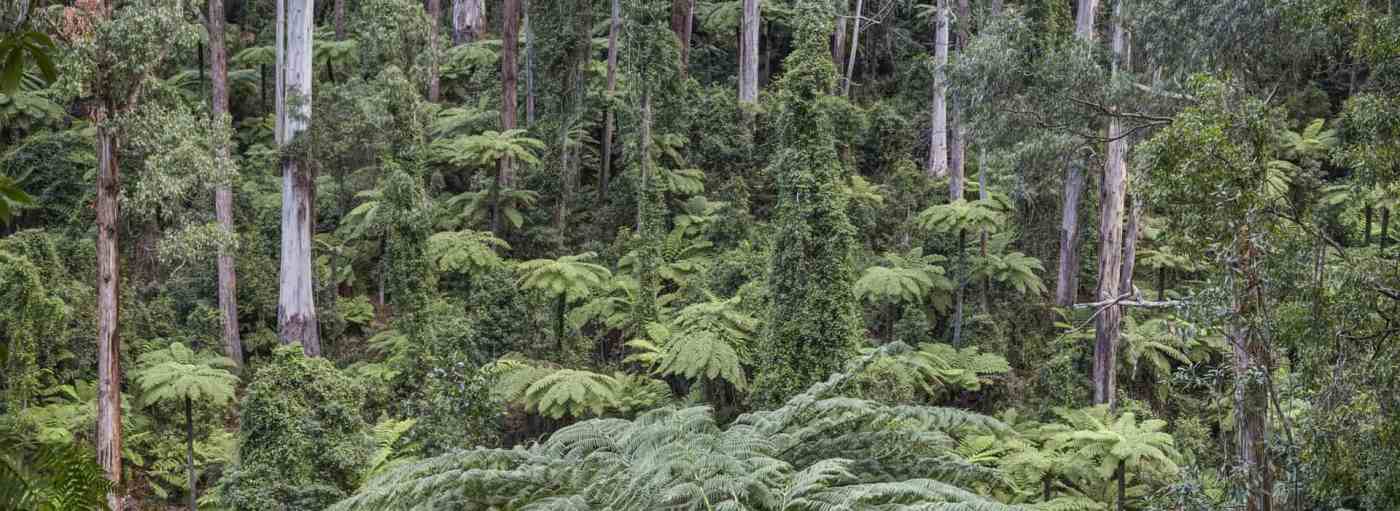
After crossing the Princes Highway, the walk climbs into the foothills where a loop commences. Walkers can choose the westerly route through Kuark Forest or continue north into Goolengook, both routes passing through ancient forest home to some of Victoria’s largest trees, enchanting fern gullies and verdant green rainforest.
Routing the trail through the Kuark Forest and the rainforest areas of the Arte River, would make good campsites easy to establish, especially in the Arte River Flora Reserve with its rare ‘overlap’ rainforest where warm and cool temperate rainforests meet.
 Existing roads in the area would easily provide vehicle access so walkers can leave or join and have an opportunity to re-supply at several points along the way.
The Goolengook route takes in the site of Victoria’s longest running forest protest. After a 20 year campaign to protect this iconic area, in 2009 Goolengook was added to Errinundra National Park.
Goolengook is Victoria’s quintessential old growth forest. Goolengook’s forests are nationally significant. They contain rare rainforest and plants such as the Slender Tree fern and habitat for endangered wildlife.
The Kuark Forest and Goolengook tracks converge on Greens Road where walkers could make a final side trip from the already established Ellery Camp to the summit of Mount Ellery.
The section of Greens Road that goes through the existing Errinundra National Park would easily be converted into a world-class hiking trail, with campsites, lookouts, side trip tracks and rangers huts along the way. The road is currently closed to vehicle traffic and would be the perfect base to establish a multi-day walk.
A walk of this size would put the region on the map and attract international and domestic tourists, seeking a true forest wilderness experience in unique environments found nowhere else on Earth.


February 4, 2018 at 9:45 am
This was a great read! I’ve never been to this part of Victoria – you have inspired me to get up that way one day. Thanks!